

 By
By Some bridges connect two banks. Others connect two futures.
Having spent decades building integrated communities across the Mumbai Metropolitan Region, I have come to see infrastructure differently from how it is usually discussed. We tend to measure a road or a bridge in kilometres, in crores spent, in minutes saved. But the real impact of infrastructure lies elsewhere. It lies in how it redraws the geography of opportunity, changing where people choose to live, where businesses choose to set up, and how a region imagines its own future.
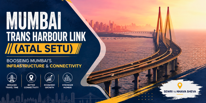
The Mumbai Trans Harbour Link, now known as the Atal Bihari Vajpayee Sewri-Nhava Sheva Atal Setu, is one of the clearest examples of this idea that the Mumbai Metropolitan Region has seen in a generation. It does not simply connect Sewri in South Mumbai to Chirle in Navi Mumbai. It connects an island city with limited land to the expanding growth corridors of Navi Mumbai and the wider MMR, and in doing so, it is beginning to reshape how this entire region will develop over the coming decade.
A Bridge Built for Scale
Atal Setu is India’s longest sea bridge, constructed by the Mumbai Metropolitan Region Development Authority (MMRDA) at a cost of approximately ₹17,840 crore. The six lane, access controlled corridor spans roughly 21.8 kilometres, of which about 16.5 kilometres run over the Arabian Sea and Thane Creek. It was inaugurated by Prime Minister Narendra Modi on January 12, 2024, and opened to public traffic the following day.
The scale of the project matters, not for its own sake, but because of what it signals: a serious, long-term commitment to treating the Mumbai Metropolitan Region as one connected geography rather than an island city and its distant satellites.
From Two Hours to Twenty Minutes: The Connectivity Dividend
Before Atal Setu, the journey between South Mumbai and Navi Mumbai could take well over an hour, often stretching past two hours during peak traffic on the Vashi Bridge and the Sion-Panvel Highway. Today, that same journey takes approximately 20 to 25 minutes.
This is not a marginal improvement. A commute that once made living or working across the harbour impractical is now well within the range of everyday life. Professionals can access opportunities on either side of the creek without reorganising their entire day around the journey, and businesses can plan around a region rather than a single side of it.
Infrastructure Takes Time to Show Its Full Impact
According to the Mumbai Metropolitan Region Development Authority, Atal Setu carried more than 8.3 million vehicles in its first year of operation, with traffic building steadily as commuters, businesses and logistics operators worked the bridge into their daily routines. That growth has continued through 2025 and into 2026, supported by the opening of Navi Mumbai International Airport and improvements such as Open Road Tolling and the exemption of electric vehicles from tolls.
I say this from experience across every large infrastructure project I have been part of: adoption is never immediate. A bridge, like a township, is not judged by its opening day traffic. It is judged by how completely it becomes part of the region’s daily life over the years that follow, as the ecosystem around it, the airport, the metro network, the townships, matures alongside it.
The Mumbai 3.0 Story: An Airport, a Metro Network and New Townships Converging
This is why Atal Setu cannot be understood in isolation. Its real significance becomes clear only when placed alongside the other systems now converging in this part of the Mumbai Metropolitan Region.
Navi Mumbai International Airport, which commenced commercial operations on December 25, 2025, needed exactly this kind of road connectivity to function as a true second gateway for the region. Atal Setu now provides a direct road link between Mumbai’s existing international airport and the new one, turning what was once a long, unpredictable cross city transfer into a signal free drive. Alongside this, the region’s expanding metro and rail network is extending reach further still, while regional planning bodies have begun identifying new areas around Panvel, Uran and Pen for logistics, technology, education, healthcare and residential development, an initiative now widely referred to as Mumbai 3.0.
No single piece of this puzzle would achieve much on its own. A bridge without an airport to connect to, or an airport without a metro network feeding it, would each fall well short of their potential. What makes this moment significant is the convergence: road, rail and air infrastructure reinforcing one another, and in doing so, opening up an entirely new growth geography for Mumbai.
A Corridor for Ports, Trade and Industry
Atal Setu’s significance extends beyond passenger travel. The bridge provides a direct link between Mumbai and the Jawaharlal Nehru Port Authority (JNPA), one of India’s largest container ports, while also connecting to the Mumbai-Pune Expressway and the Mumbai-Goa highway corridor. MMRDA has continued to strengthen this network, with construction under way on a direct connector between Atal Setu and the Mumbai-Pune Expressway, intended to further ease the movement of both passenger and freight traffic between the region’s two largest economic centres.
For an industrial base that has long depended on efficient access to Mumbai’s ports and markets, a direct sea link changes the calculus considerably, for logistics companies, for manufacturers and for the wider Konkan region.
Growth and Environmental Responsibility, Together
Infrastructure of this scale inevitably raises a fair question: at what cost to the natural environment it passes through? Atal Setu offers a useful example of how that question can be answered thoughtfully rather than dismissed.
The stretch of coastline near Sewri is home to migratory flamingos that arrive on the mudflats each year, and the bridge’s design incorporates a dedicated silent zone, with noise and vision barriers, to minimise disturbance to their habitat. It is a small design choice in the context of a 21.8 kilometre structure, but it reflects a principle I believe should guide all large-scale development: growth and environmental responsibility are not competing priorities to be traded off against each other. They have to be planned for together, from the outset, not added on as an afterthought.
What Gets Built Around a Bridge Matters More Than the Bridge Itself
This brings me to the point I consider most important, and the one that infrastructure conversations often miss.
A bridge, an airport or a highway creates the conditions for growth. It does not, by itself, create a better quality of life. That depends entirely on what gets built around it: the townships, schools, hospitals, workplaces and public spaces that turn improved connectivity into an actual place where people can live well. Infrastructure opens a door. Planning decides what is on the other side of it.
This is the thinking that has shaped Panvel real estate over the past decade, and specifically the vision behind Hiranandani Fortune City Panvel, conceived as an integrated township at a time when much of the infrastructure now transforming this corridor was still on paper. The intent was never to wait for demand to become obvious and then respond to it, but to plan for the region Panvel was becoming, with residential development alongside healthcare, education, recreation and commercial space, so that when connectivity did arrive, the community around it was already equipped to make use of it. Atal Setu has not created that idea. It has simply reinforced why it matters.
The Real Measure of a Bridge
An engineer measures a bridge by its span, its load capacity and its design life. I measure it differently.
The real measure of Atal Setu will be in how many opportunities it makes possible over time: for the professional who can now consider a home across the harbour, for the business that can move goods to port in a fraction of the time, for the family that can reach a new airport without losing half a day to traffic, and for a region that can finally grow as one connected geography rather than two separate halves of a city.
That is the true promise of Atal Setu. Not merely a bridge across the sea, but a bridge into the next chapter of the Mumbai Metropolitan Region’s growth.
Frequently Asked Questions
What is the Mumbai Trans Harbour Link, and why is it also called Atal Setu?
The Mumbai Trans Harbour Link is India’s longest sea bridge, connecting Sewri in South Mumbai to Chirle in Navi Mumbai. Its official name is the Atal Bihari Vajpayee Sewri-Nhava Sheva Atal Setu, named in honour of former Prime Minister Atal Bihari Vajpayee, and it is commonly referred to simply as Atal Setu. It was inaugurated by Prime Minister Narendra Modi on January 12, 2024, and opened for public use the following day.
How long is Atal Setu, and how much time does it save commuters?
The bridge spans roughly 21.8 kilometres, with about 16.5 kilometres running over the Arabian Sea and Thane Creek and the remainder on elevated land approaches. It has reduced the journey between South Mumbai and Navi Mumbai from well over an hour, often close to two hours in peak traffic, to approximately 20 to 25 minutes.
How does Atal Setu connect to Navi Mumbai International Airport?
Atal Setu provides a direct road link between Mumbai’s existing international airport and Navi Mumbai International Airport, which became operational in December 2025, turning what was once a long, unpredictable cross city transfer into a signal free drive.
What has traffic on Atal Setu looked like since it opened?
According to the Mumbai Metropolitan Region Development Authority, the bridge carried more than 8.3 million vehicles in its first year of operation, with traffic continuing to build through 2025 and into 2026. As with most large infrastructure, usage is expected to keep growing as the surrounding ecosystem, including the airport, metro network and new townships, matures.
Is Atal Setu driving real estate growth in areas like Panvel?
Atal Setu has meaningfully improved accessibility to areas such as Panvel, Ulwe and the wider Uran belt, and this is one of several factors, alongside Navi Mumbai International Airport and regional planning initiatives, contributing to growing interest in the region. It is best understood as one part of a broader set of infrastructure developments now shaping what is being described as Mumbai 3.0, rather than the sole driver of that trend.
Follow Us On Social Media:
Discover more from Niranjan Hiranandani
Subscribe to get the latest posts sent to your email.